Conservation Area (CA)
The Avenues CA / Brunswick Town CA
Local Listing Reference
LLHA0107
Description
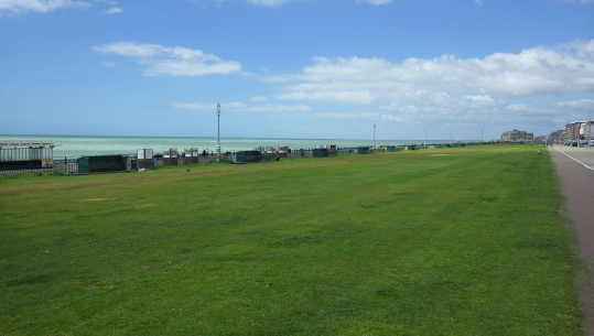
Hove Lawns is the general term used to describe the lawns along the length of much of Hove’s seafront. It includes the section from the Brighton boundary to St John’s Road (called Brunswick Lawns); and that from St John’s Road to Fourth Avenue (named King’s Lawns - previously the West Brighton Estate Lawns). They were laid out in conjunction with the housing developed to their immediate north. As such, the 1830 Act associated with the construction of the Brunswick Estate laid down that no building should be erected to the south of Brunswick Terrace. The lawns were used for promenading by the fashionable set into the 20th century. The West Brighton Estate Lawns were originally for private use by those living to the north. Hove Council took over their maintenance in 1948, when they became accessible to the public. The Lawns comprise of an open tract of grassed lawn, intersected by linear paths that access the seafront. There is no boundary to the north; that to the south is formed by either a retaining wall or railings (the latter were erected in c.1901). The west boundary has cast iron railings (assessed separately). Historic mapping shows that the designs of the Lawns have changed little over time, although there is evidence to suggest they may have originally been sloping rather than all flat. King’s Lawns originally had planting (hedge and flower beds) to its north boundary, which was still in place in 1949. A hydraulic engine situated beneath the lawns originally supplied sea water to some of the residences to the north. There are two shelters located at the south side of the Lawns in line with The Drive. These are replicas of historic shelters; the originals were blown down in the hurricane of 1987. Source: Middleton 2002
B. Historic and Evidential Interest
ii. Illustrative of the development of the seaside resort and changing role of the seafront promenade over time
C. Townscape Interest
i. Within conservation areas, the Lawns are unusual in being open green spaces within the urban area, which form an integral part of the Hove seafront
iii. The openness of the Lawns provides a marked contrast to Brighton seafront, providing a clear sense of place.
iv. Associated with the listed buildings that line the north side of Kingsway
F. Intactness
i. The Lawns retain their open character and relationship with both the sea and listed buildings to the north
Date of Inclusion
2015