Information and Brighton & Hove City Council details
Local authority officer
Samuel Rouse
Department
Regulatory Services
Address
Hove Town Hall, Norton Road, Brighton & Hove BN3 3BQ
Email and phone
Report Reference Number
ASR 2025
Date
June 2025
Download the 2025 Air Quality Annual Status Report (ASR) as a PDF or continue reading this accessible web version.
Local responsibilities and commitment
Regulatory services at Brighton & Hove City Council completed this Annual Status Report (ASR).
The regulatory services remit includes environmental health and licencing, air quality, enquiries about dust and smoke, statutory nuisance, licencing of taxis and pubs, permitting of Part B industrial processes such as crematorium, food premises inspections and trading standards.
The broader City Infrastructure directorate including, transport and parking support specific measures set out in the Air Quality Action Plan (AQAP), Table 2.2 (update 2025).
Air quality has strong cross over to public health, net zero, planning and our communications team. Partnership working is well established across Sussex and with DEFRA. Air quality assessment and associated action planning has been part of more than one directorate at the unitary authority. The Principal Air Quality Officer has experience of writing LAQM reports over eighteen years. Content shared with Sussex Air Quality Partnership throughout the year. The Director of Public Health (DPH) has previously signed the ASR for air quality and is familiar with the format. Senior public health consultants and our web content team have seen this edition prior to online publication.
If you have any comments on this annual report for air quality, contact the Regulatory Services Team.
Executive summary
This report supports the council’s aims of being a learning organisation. Evidence-based reports educate and raise awareness. As collaborative behavioural change chooses cleaner options for home heating and travel, this will deliver a healthier environment for all. Long term trends for a reduction in airborne pollution can help to reduce inherent inequalities between neighbourhoods.
In this report, monitoring evidence of local air up to the end of the 2024 calendar year. Updates to the action plan are to the time of writing.
Diesel vehicles dominate concentrations of the toxic pollutant Nitrogen dioxide (NO2) gas). Fixed diesel generators and gas boilers also make a significant contribution to gas pollution monitored citywide. Work continues to progress the phasing out relatively polluting emission sources.
A comprehensive list of measures in the action plan refresh, table 2.2.
Long term (a decade and more) NO2 levels show substantial improvement.
At Coombe Terrace, Lewes Road for example (A270) monitoring indicates constant concentrations since 2020 to 2021; the years influenced by travel restriction associated with the COVID-19 pandemic.
Across Sussex, examples show evidence of a slight increase in 2024 NO2, compared to 2023. Identified locations show an observed increase in the count of certain vehicle types (bus, light commercial and motorbike since that time).
Whilst local car counts have increased since 2020 to 2021, they have not exceeded pre-pandemic traffic numbers.
Whilst UK air quality standards and legal limits are met throughout the city, concentrations continue slightly below this threshold adjacent to parts of AQMA1 (Air Quality Management Area), A270-Lewes Road and A23- London Road and close to the Clock Tower slope next to B2066, North Street, bus-ULEZ.
Essential to further improve air quality are cleaner alternatives to diesel. Delivery of a healthier local environment can surpass the 2026 air quality target set out in the Air Quality Action Plan and achieve the 2030 European legal limit for NO2 across a higher proportion of the city.
The local authority has responsibility to reduce fine Particulate Matter (PM2.5) including visible smoke. Local sources include ships at dock, domestic solid fuel, and waste burning.
Progress during the past 12 months has helped to reduce and avoid emissions harmful to health. The council has increased the number of regulatory standard automatic analysers monitoring gases and particles from 2 to six and introduced a regional network of 50 real-time pollutant sensors, 40 of which are within Brighton & Hove. For 2024 60 diffusion tubes monitored NO2 in around declared Air Quality Management Areas throughout the calendar year.
Air quality in Brighton & Hove
Breathing in polluted air affects our health and costs the NHS and our society billions of pounds each year. The government recognises that air pollution is a contributing factor in the onset of heart disease and cancer and can cause a range of health impacts, including effects on lung function, exacerbation of asthma, increases in hospital admissions and mortality.
Air pollution particularly affects the most vulnerable in society, children, the elderly, and those with existing heart and lung conditions. Low-income communities often are disproportionately impacted by poor air quality, exacerbating health and social inequalities.
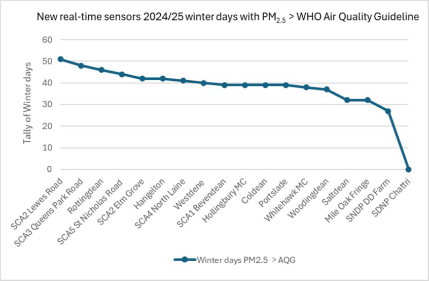
Below we provide a brief explanation of the key pollutants relevant to Local Air Quality Management and the kind of activities they might arise from. In the local environment (real-world) the impact on human health will be a mix of NO2 and particles. New monitoring installed 2024 and 2025 (action to include results in future year trend charts).
Description of key pollutants
Nitrogen Dioxide (NO2)
Nitrogen dioxide is a gas emitted from high-temperature combustion processes such as road transport or energy generation. Effective hot catalysts mitigate emissions to meet stricter emissions standards for vehicles and gas boilers. For Brighton & Hove (urban area) NO2 is the most plentiful pollutant in the local environment. The reason why, Local Air Quality Management (LAQM) has often targeted efforts and reporting.
The main health impact of NO2 is on the respiratory system. Inhalation through childhood can influence lung tissue growth, lifelong lung capacity and lung function. Dose and exposure to NO2 can increase the risk of respiratory infection. Nitrous oxides can contribute to acid rain and damage, crops, and protected habitats. The city council started monitoring NO2 in 1995.
Particulate Matter (PM10 and PM2.5)
Particulate matter is everything in the air that is not a gas.
Particles can come from natural sources such as pollen and sea salt and human made sources such as smoke from fires (outdoors and in a hearth), emissions from industry, ships and aviation. Dust from demolition, tyres and brakes can be coarser dust compared to the fines and ultra-fine particles emitted due to combustion and smouldering.
PM10 refers to particles under 10 micrometres. Fine particulate matter or PM2.5 are particles under 2.5 micrometres or microns.
Sulphur Dioxide (SO2)
Sulphur dioxide (SO2) is a corrosive gas, from the combustion of coal or oil derivatives such as bitumen. Prior to 1995 SO2 contributed to transboundary acid rain.
In 2024 the UK’s last coal fired station, ceased to operate.
Concentrations are low in Brighton & Hove. During 2024 new monitoring at portside and roadside to compare levels with the South Down National Park (SDNP) that has Automatic Urban Rural Network (AURN) monitor at Lullington Health.
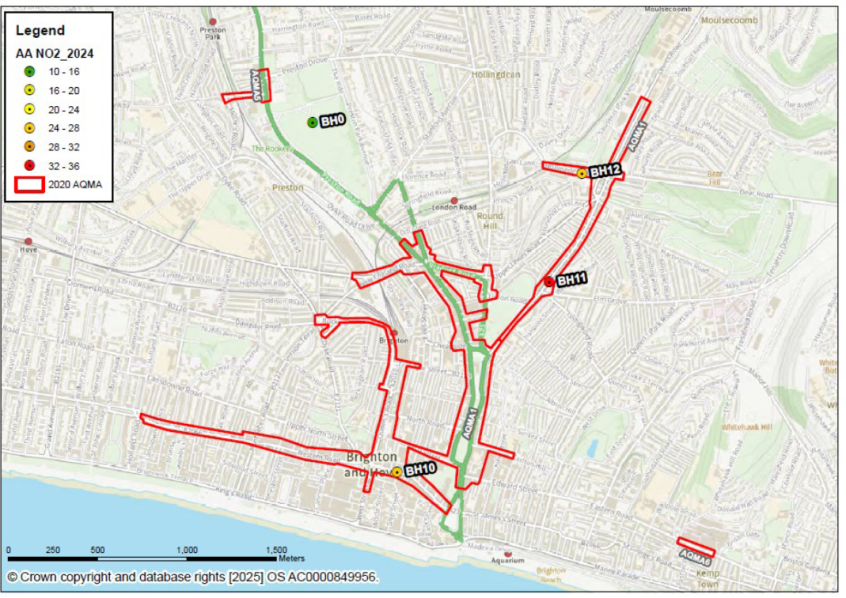
League table of priority areas (NO2) compared to background
Highest NO2 monitoring results 2024 across designated areas compared with locations not at roadside (background that is the environment in parks or on the sea front).
| Highest results in each area | Monitor ID (road name where relevant) | Site type | Valid data capture 2024 (%) | SDNP level times how much? | NO2 2024 |
|---|---|---|---|---|---|
| AQMA1 Lewes Road | A270 E07-2019 | Roadside | 86.8 | 7.9 | 37.9 |
| AQMA1 London Road-Oxford Street | A23 C18-2010 | Roadside | 86.8 | 7.6 | 36.7 |
| AQMA1 North Street | B2066 C11-2012 | Roadside | 86.8 | 7.3 | 35.1 |
| AQMA1 New England Road | A270 C25-2010 | Roadside | 86.8 | 6.9 | 33.2 |
| AQMA1 Viaduct Road | A23 C21-2005 | Roadside | 86.8 | 6.4 | 30.9 |
| AQMA1 Edward Street-Pavilion Parade | C-Link E17-2018 | Roadside | 86.8 | 6.4 | 30.6 |
| AQMA1 Grand Parade | A23 E16-2015 | Roadside | 78.0 | 6.4 | 30.6 |
| AQMA1 Old Shoreham Road East End | A270 W05-2006 | Roadside | 86.8 | 6.3 | 30.0 |
| AQMA1 Dyke Road-Churchill Square | C-Link C13-2014 | Roadside | 79.3 | 6.2 | 29.9 |
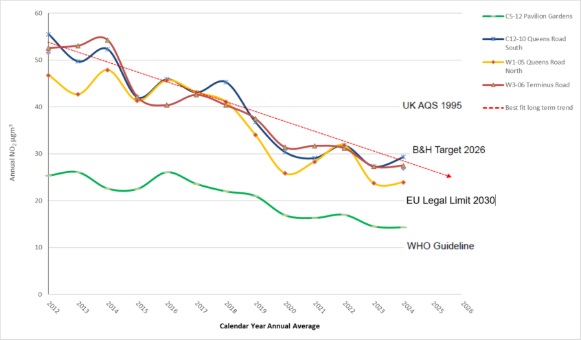
| AQMA1 Queens Road | A2010 C12-2010 | Roadside | 86.8 | 6.1 | 29.3 |
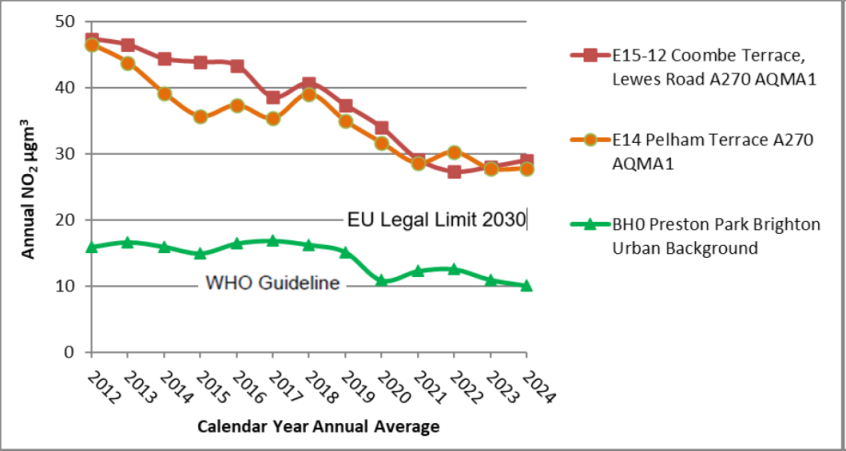
| AQMA1 Lewes Road-Coombe Terrace | A270 E15-2012 | Roadside | 86.8 | 6.0 | 29.0 |
| AQMA1 York Place | A23 C16-2013 | Roadside | 86.8 | 6.0 | 29.0 |
| AQMA5 The Drove-South Road | C-Link E02-2012 | Roadside | 78.5 | 6.0 | 28.7 |
| AQMA1 Chatham Place | B2122 W04-2006 | Roadside | 86.8 | 5.9 | 28.2 |
| AQMA1 Terminus Road | A2010 W03-2006 | Roadside | 86.8 | 5.7 | 27.5 |
| AQMA3 South Portslade | A259 W16-2020 | Roadside | 86.8 | 5.6 | 27.1 |
| AQMA3 Trafalgar Road | A293 W19-2009 | Roadside | 86.8 | 5.5 | 26.5 |
| AQMA3 Old Shoreham Road | A270 W20-2021 | Roadside | 86.8 | 5.5 | 26.5 |
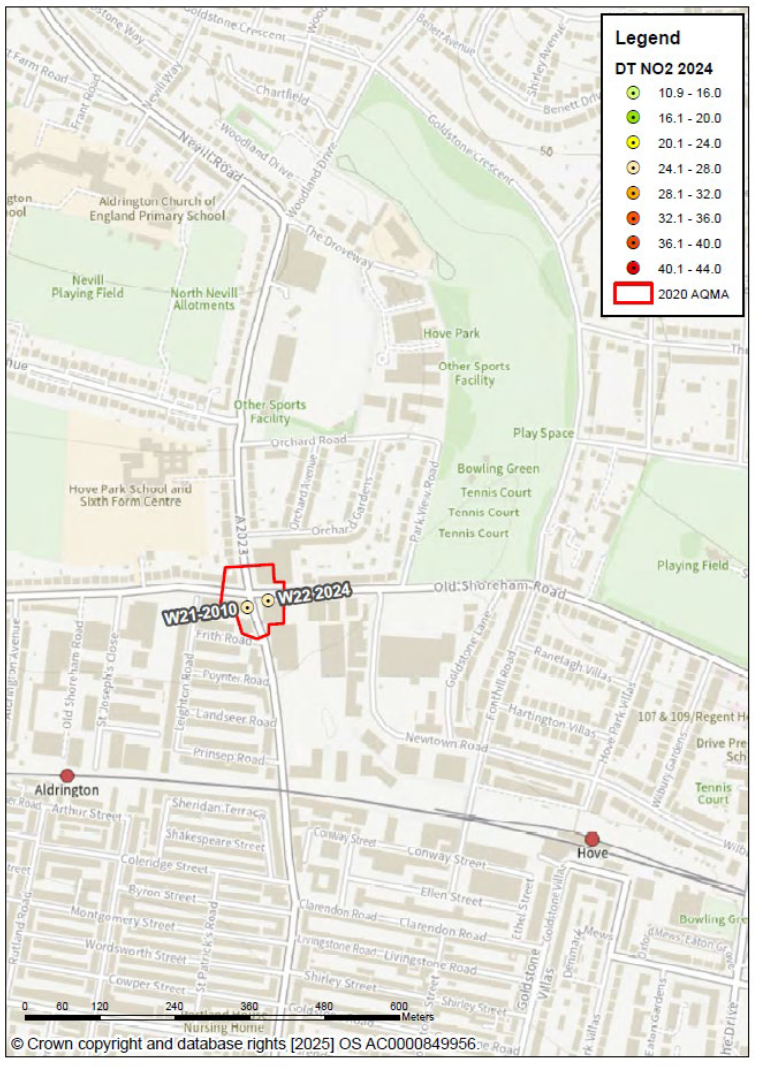
| AQMA4 Old Shoreham Road | A270 W22 2024 | Roadside | 86.8 | 5.3 | 25.6 |
| AQMA4 Sackville Road North | A2023 W21-2010 | Roadside | 86.8 | 5.3 | 25.5 |
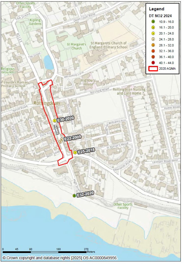
| AQMA2 Rottingdean | B2123 E23-2010 | Roadside | 86.8 | 5.3 | 25.3 |
| AQMA1 Old Steine West | A23 C02-2022 | Roadside | 86.8 | 4.7 | 22.7 |
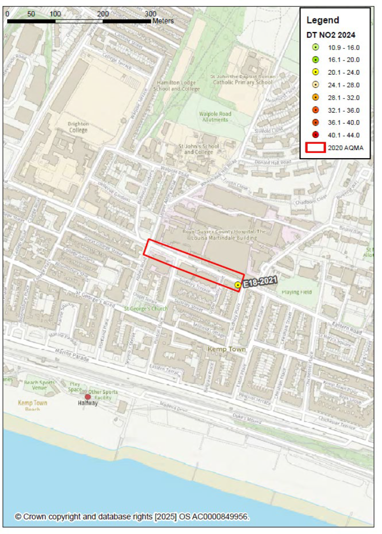
| AQMA6 County Hospital | C-Link E18-2021 | Roadside | 86.8 | 4.2 | 20.2 |
| Central Brighton Background | C05-2012 | Urban Background | 86.8 | 3.0 | 14.3 |
| Portslade Vale Park Background | W18-2010 | Urban Background | 86.8 | 2.8 | 13.4 |
| Rottingdean Beach Background | E32-2020 | Urban Background | 86.8 | 2.3 | 10.9 |
| Preston Park Background | BH0 | Urban Background | 99.1 | 2.1 | 10.1 |
| South Downs National Park Background | LL AURN | Regional Background | 95.7 | 1.0 | 4.8 |
The Souths Down National Park (SDNP) surrounds the Brighton & Hove urban area; it is a helpful “barometer” of regional air quality and local emissions add to this environment. Particulate levels are less geographically variable than NO2, that said monitored differences detected between the urban area and the SDNP. Further work continues since the installation of additional analysers and real-time sensors, new for 2024. Recorded PM2.5 concentrations achieve 2040 UK targets across the city. Continued actions will achieve the World Health Organisation guidelines, published in 2021.
Whilst air quality has improved significantly in recent decades, there are areas where local action is required to protect people and the environment from the effects of air pollution.
Priority areas and travel corridors
The following AQMAs declared for NO2 are priority for reduction in oxide of nitrogen, due to diesel emissions. Along recognised travel corridors source apportionment varies between heavy good vehicles, bus, minibus-taxi, vans, cars and motorbikes.
As daily commuting and “rush-hour” diminished from 2020, the contribution to roadside pollution from service vehicle trips, 24-hours has become more significant. An increasing proportion of deliveries and collections are made with cycles, e-bikes and e-vehicles, with potential for drones to play their part with deliveries and event entertainment.
That said in 2025, diesel still account for most road service trips, required to move goods and passengers. Electrified railways are one of the most sustainable ways to move freight and people with minimal emissions.
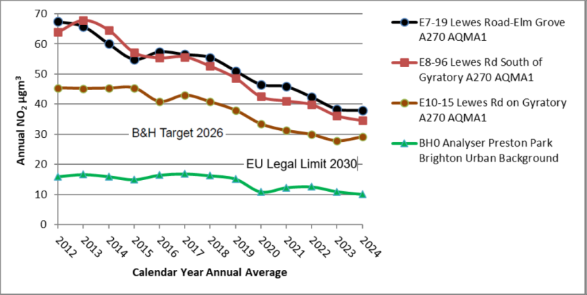
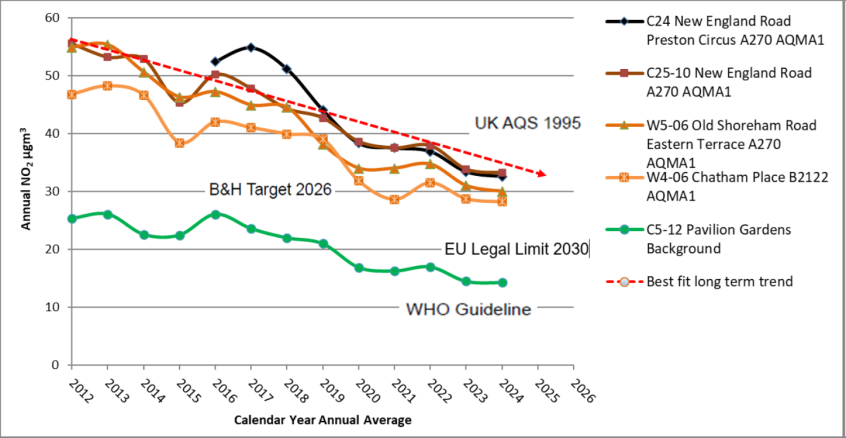
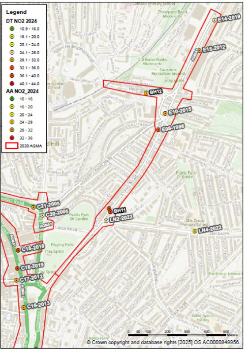
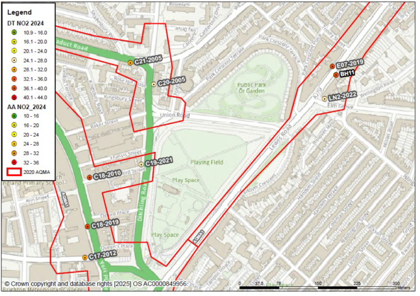
AQMA1 A270 Lewes Road - New England Road and Hollingdean Road
For the first time in 2023 (and 2024), local monitoring suggests UK air quality standards (1995) are achieved in Brighton & Hove. During the past year roadside NO2 concentrations have levelled at residential sample East-7, near Elm Grove next to Lewes Road (A270). Long term trends in NO2, presented in section 3.2.1. 2024 NO2 recorded at 38 μg/m3, is higher than elsewhere in Brighton & Hove. It is essential that pollution levels continue to improve. Road users are gradually becoming cleaner.
Observations regarding the Lewes Road corridor specifically:
- shuttle route between city centre and university campus at Moulsecoomb and Falmer and a key connection with East Sussex, Lewes, Uckfield, Eastbourne and surrounding villages
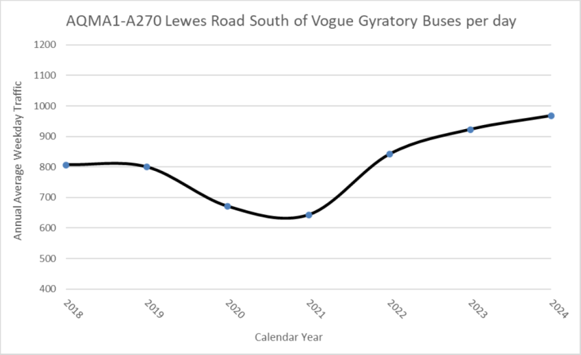
- an increase in bus numbers using the Lewes Road corridor since 2021, up from 643 per day in that year to 968, 2024 (annual average weekday traffic)
- 2024 to 2025 not all bus services along the A270 route, met bus-ULEZ standards (all London buses achieved this emission standard as minimum January 2021)
- a lack of geo-fenced zero capable or electric buses along the Lewes Road corridor
- an increase in light commercial vehicles using the corridor; 2024 more than the 2019 average
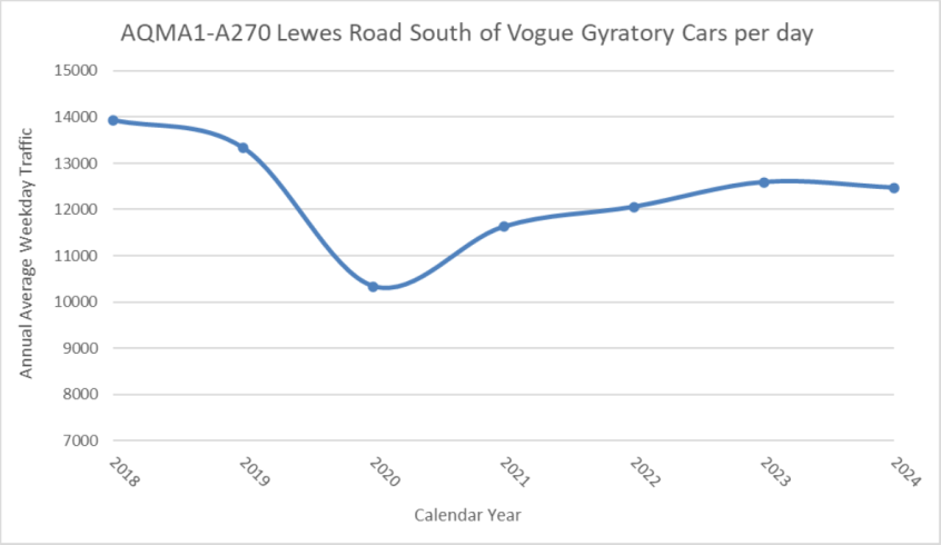
- whilst car counts have not reached pre-pandemic levels their numbers using the Lewes Road south of the Vogue Gyratory have increased since 2020 to 2021
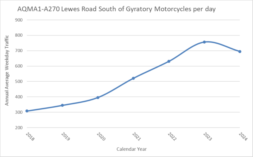
- since COVID-19 a doubling in the number of motorbikes along the Lewes Road up from 308 per day 2018 average, to 756 and 695, 2023 and 2024 averages - high proportion of these are scooters associated with food delivery - recommended that operators incentivise electrification of the group and advertise this to clients
- in total 15,532 vehicles using the travel corridor each weekday (2024 average). Changes to bus and light commercial vehicle counts are most significant for emissions (compared to the previous situation) and the requirement to keep improving air quality
Trend graphs showing long term daily traffic (Monday to Friday) in AQMA1 - A270 Lewes Road
AQMA1-A270 Lewes Road South of Vogue Gyratory buses per day
AQMA-A270 Lewes Road South of Gyratory motorcycles per day
AQMA1-A270 Lewes Road light commercial vehicles per day
AQMA-A270 Lewes Road South of Vogue Gyratory cars per day
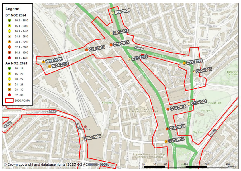
Additional pollutant monitoring (oxides of nitrogen and particles) added to Lewes Road and Hollingdean Road during 2024. This will collect continuous data 2025 and produce complementary results for the annual report, July 2026. New England Road is also part of the A270 east-west route via Preston Circus. This road-link can have long durations of queuing cars and vans. Outside of the covered bridge area (without houses), in 2024 residential façade NO2, recorded at 33 μg/m3 annual average.
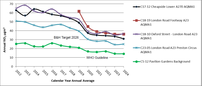
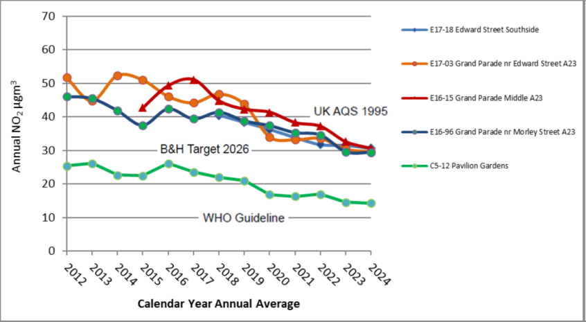
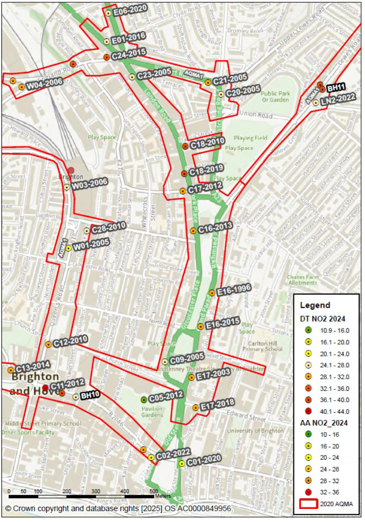
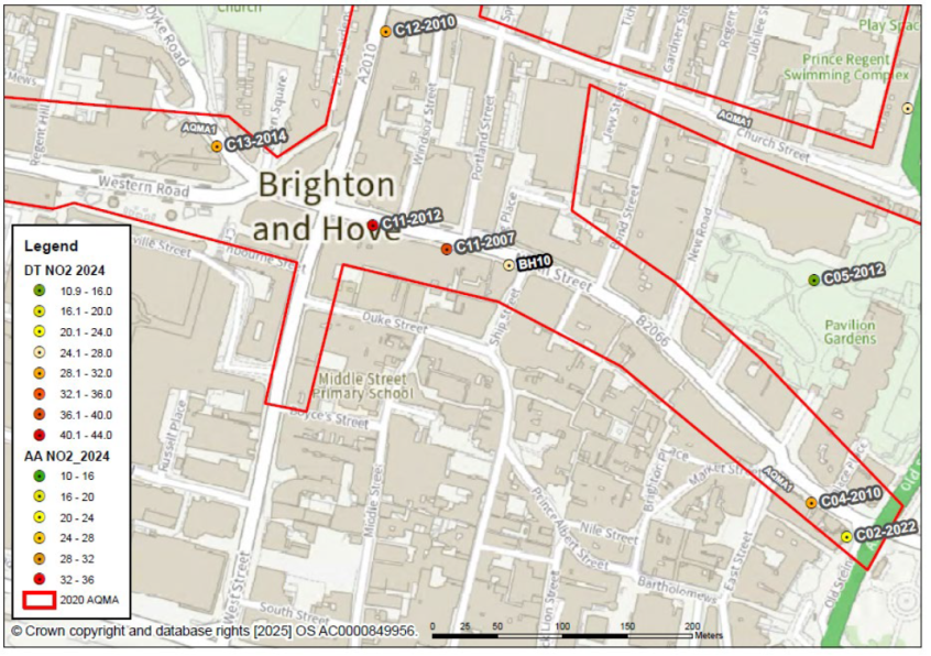
AQMA1 A23 London Road Viaduct Road - Grand Parade to Edward Street
2024 monitoring indicates the London Road area has the second highest local NO2 at 37 μg/m3 annual mean, this is on the façade of Oxford Street next to London Road.
Pedestrian footfall is high, the homeless spend time in the area sitting outside shops and hundreds of people wait for buses.
London Road has a mix of vehicle types and in 2025 heavy and light diesel vehicles (euro, four, five and euro six) continue to use the corridor. New cameras installed 2024 aim to characterise vehicles in the AQMAs by emission and fuel type.
Viaduct Road and Grand Parade are also part of the A23 corridor both-ways, carry general traffic including cars, small vans, and heavier commercial vehicles (no bus routes). Further vehicle emissions reductions to achieve 2026 air quality targets.
Further improvements to Valley Gardens aim to make the area more accessible and attractive for active travel (walking, cycling, wheeling and e-bikes). Investment in sub-stations would facilitate vendors and organised events to plug-in and phase out diesel generators.
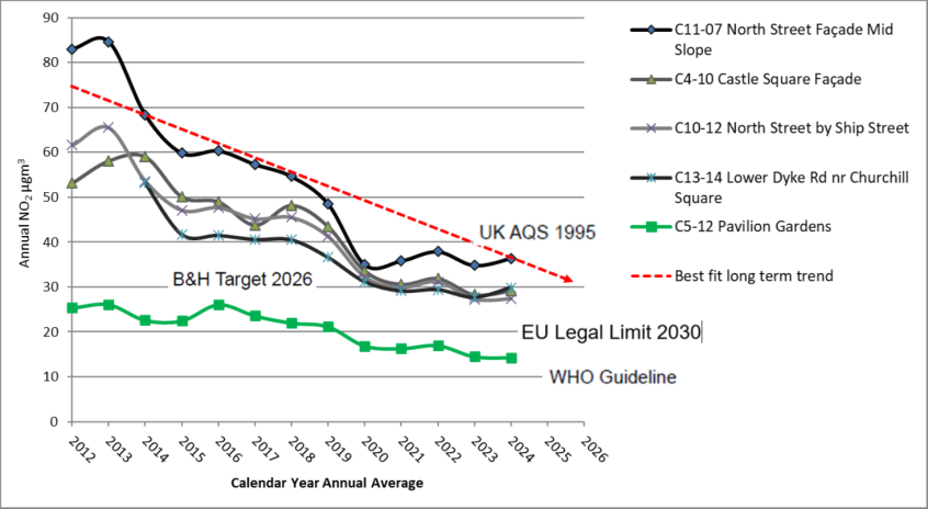
AQMA1 B2066 Bus-ULEZ North Street
The monitoring undertaken up to 2025 indicates this travel corridor is third highest local area for 2024, NO2 at 36 μg/m3 annual average on the building façade opposite Windsor Street, which includes a slight increase since 2023. Higher concentrations, at lower heights (metres) and on the pavement that has thousands of pedestrians every day. Monitoring indicates UK air quality standards achieved in this area, from 2020. Emission reductions including cleaner buses to keep pollutant levels (NO2) on track with the AQAP 2026 target of 30 μg/m3 annual mean or 3-year average.
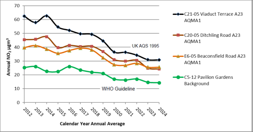
AQMA1 A2010 Queens Road and Terminus Road
Continuous with bus-ULEZ pollution levels has improved over recent years. 2024 monitoring indicates the fourth highest local area for NO2 slightly above 29 μg/m3 annual average. Monitoring indicates UK air quality standards achieved in this area, from 2020 (sustained for 2 years not including the abnormal 2020 to 2021 years affected by COVID-19 travel restrictions).
The rate of improvement in gaseous pollution (12 year best fit line included) has slowed since 2020. Further improvement to surpass the 2026 target beyond all reasonable doubt, and to be on track with the 2030 target.
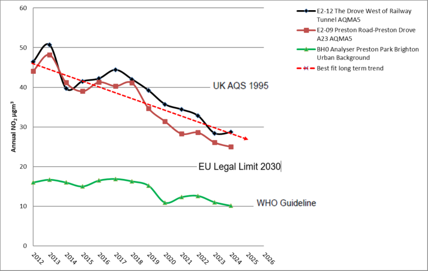
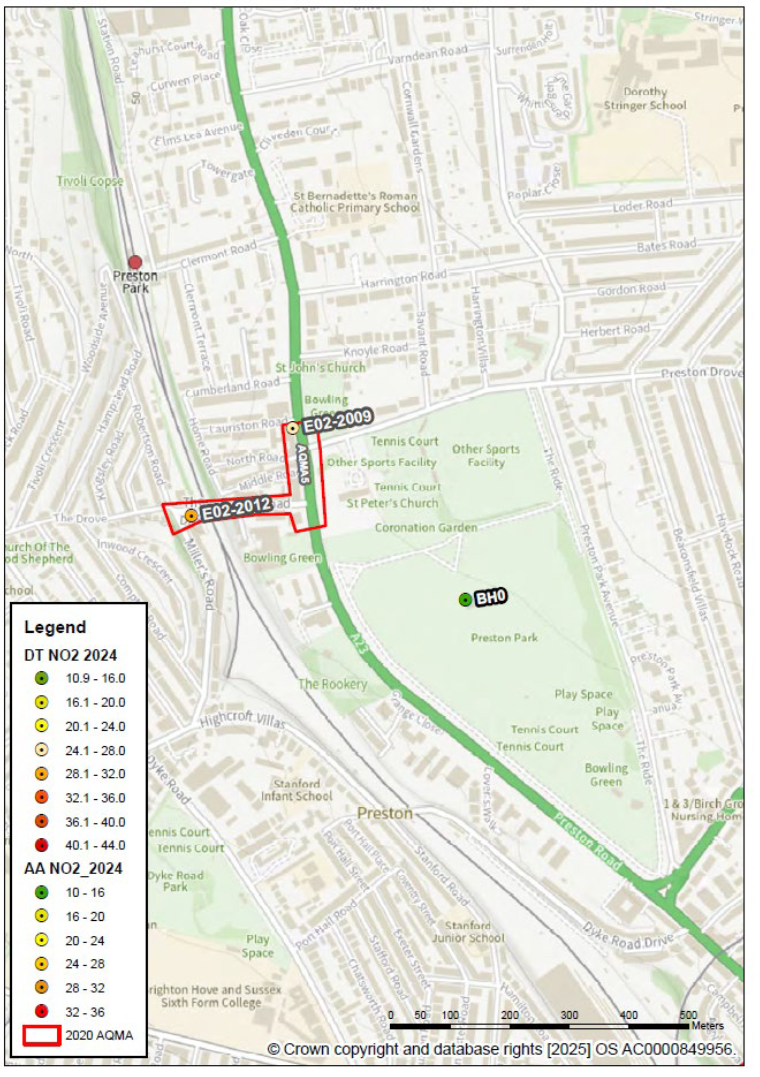
AQMA5 The Drove-South Street
2024 monitoring indicates the fifth highest local area for NO2, slightly below 29 μg/m3 annual average. Monitoring indicates UK air quality standards achieved in this area, from 2023. Further road traffic emission reductions (diesel vans and cars) on the hill climb to work towards pollutant levels (NO2) below European legal limits, 20 μg/m3.
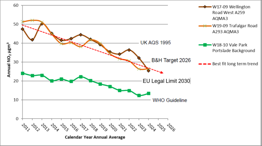
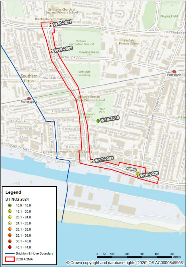
AQMA3 A293-A259-A270 South Portslade
2024 monitoring indicates the sixth highest local area for NO2, 27 μg/m3 annual average. Monitoring indicates UK standards levels from, 2020 and local targets achieved 2024. HGV and diesel car emission reductions to ensure pollutant levels (NO2) continue below the AQAP 2026 target of 30 μg/m3 and achieve the EU level.
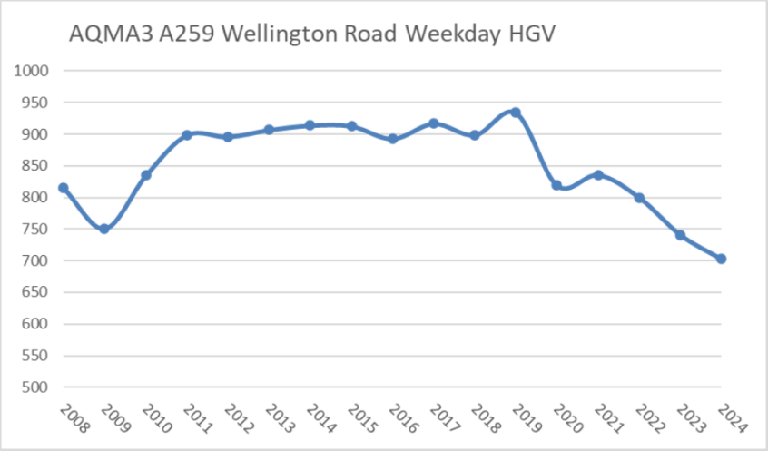
Trend graph since 2008, showing daily (Monday to Friday) Heavy Good Vehicle counts in AQMA3, A259 haulage route to Shoreham Port
AQMA4 A2023-A270 Sackville Road-Old Shoreham Road
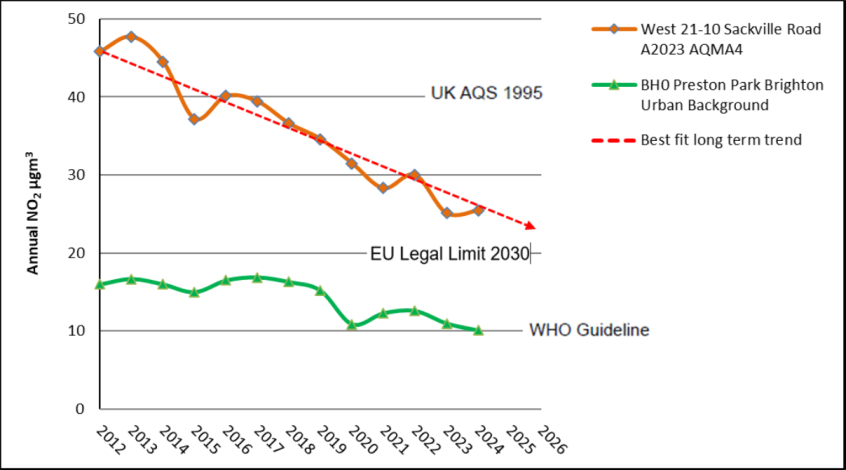
2024 monitoring indicates the seventh highest local area for NO2, 26 μg/m3 annual average. Monitoring indicates UK standards achieved in AQMA4 from 2019 and local targets from 2023. Traffic monitored at the junction as major developments proposals within 1km. Further emission reductions and a continued improving trend to achieve the EU ambient level of 20 μg/m3, ahead of 2030.
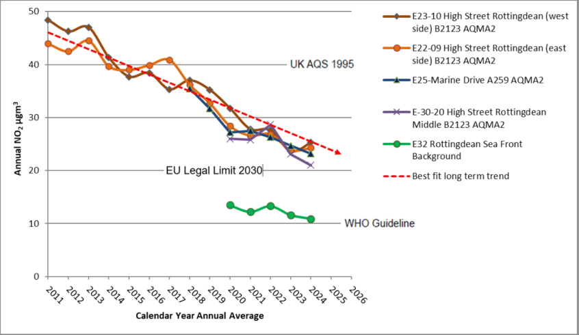
AQMA2 B2123-A259 Rottingdean High Steet
2024 monitoring indicates the eighth highest local area for NO2, 25 μg/m3 annual average (worse case monitor). Monitoring records show the confined High Street with housing inches from the carriageway, has sustained improvement in outdoor pollution levels. Long term diffusion tubes indicate UK standards achieved from 2019 (beyond on reasonable doubt) and local targets since 2021. Further diesel emission reductions (heavy and light vehicles) to achieve the EU outdoor level of 20 μg/m3 ahead of 2030. A slight increase in 2024 compared to 2023 and new monitoring position added 2025, to be considered prior to any revocation of AQMA2.
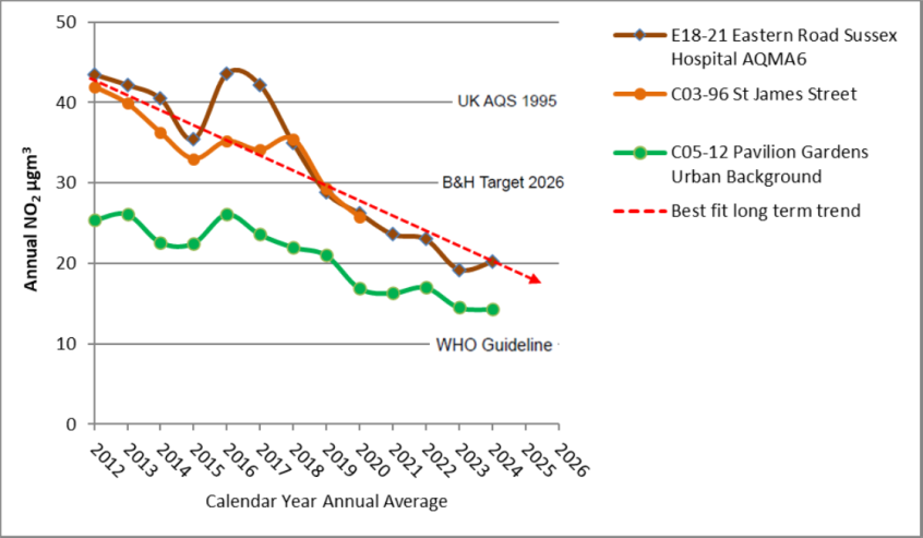
AQMA6 Eastern Road special case between infirmary buildings
2024 monitoring indicates the ninth highest local area for NO2, at 20 μg/m3 annual average. UK standards and local targets achieved since 2019. In 2024 a new traffic camera to assess vehicle emission categories. Buses operate as geo-fence zero in the area. In 2025 a new diffusion tube site put in place, located at the western part of AQMA6. More stringent air quality standards should apply at the infirmary with trauma, cancer unit and neo natal healthcare. Recommendation to retain the existing AQMA, until such time European legal limits, 20 μg/m3 NO2 happen for 5 years. Construction emissions at the hub hospital have influenced local air quality. By 2025 NHS contractors have nearly completed these activities.
Clean air park and gardens
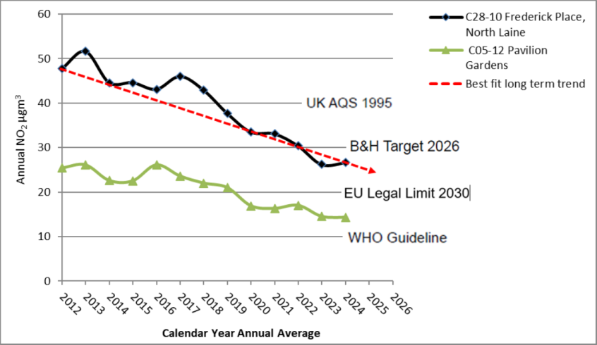
Other areas of the city such as school grounds and most residential areas achieve the 2030 EU legal limit. In Brighton & Hove continuous monitoring indicates that in 2024, larger parks and gardens meet the WHO guideline for NO2, that is 10 μg/m3 annual mean.
Conclusions and priorities
Initially AQMAs declared 2004 in Brighton & Hove. The council monitors inside and outside the AQMAs. In recent years, Brighton & Hove City Council has detected no exceedances outside of the AQMAs (amended 2020). Currently there is no need to declare new areas. During the past 12 months consideration given to the possibility of AQMA4, AQMA2 and AQMA6 revocation.
Another year of monitoring at new and existing locations within the current AQMAs will confirm if monitored levels are representative. Improving long term trends are described and presented in charts as part of this ASR. The Environment Act 1995 initially set UK air quality objectives that became legally binding standards in 2010. The council’s AQAP aims to achieve interim health-based targets by 2026, followed by levels agreed by the European parliament 2030 target. This level is met in most suburbs and residential areas of Brighton & Hove City Council. Parts of AQMA1 require measures set out in the AQAP to keep on track with Key Performance Indicators (KPIs).
Local engagement and how to get involved
Everyone can do their little bit to help improve local air quality in their city. For example, the travel and heating choices people make have an adverse or beneficial influence on the air everyone breathes:
Healthy Travel Choice Hierarchy
- Active Travel – walking, cycling and wheeling (roller booting).
- Battery assisted bicycles.
- Public Transport.
- Electric car or van
- Battery vehicle with a range extender
- Petrol‐electric hybrid
- Small Petrol engine
- Diesel hybrid
- Diesel with effective exhaust mitigation
- Diesel without exhaust mitigation
Healthy Heating and Cooling Hierarchy
- Building with modernised energy performance to reduce winter energy demand, passive design to assist heating and cooling with street and room ventilation
- Renewably generated electricity without combustion, energy storage and grid-balancing between buildings and vehicles
- National grid complemented with microgeneration such as roof top solar panels, zero emissions to air
- Ultralow NOx biogas fuelled boilers
- Ultralow NOx natural gas fuelled boilers
- Combined Heat and Power (CHP) gas combustion (emits NOx and CO2, not as clean as the national grid in 2025
- Exempt stoves and appliances risks smoke with intermittent burning practices
- Pellet stove (lower emission compared to log burners)
- Seasoned dry wood or anthracite
- Aga oil or kerosene burning
- Fixed diesel generators such as auxiliary back up with risk of smoke
- Damp wood and open fireplaces
- Heavy fuel oil with various emissions
- Waste burning
- Traditional house coal with sulphurous emissions (illegal to sell in England)
1. Local air quality management
This report provides an overview of air quality in Brighton & Hove City Council (BHCC) up to and including 2024. It fulfils the requirements of Local Air Quality Management (LAQM) as set out in Part IV of the Environment Act (1995), as amended by the Environment Act (2021), and the relevant Policy and Technical Guidance documents.
Progressive local authorities such as Oxford, Cambridge, BHCC and London Boroughs have pledged to work towards more ambitions air quality targets. This initiative-taking approach considers current understanding of the health risk of airborne pollution, including medical research evidence published in the thirty years since objectives were set out by the Environment Act (1995).
At the current time, hourly NO2 > 150 μg/m3, is unusually high. Recommended that air the daily air quality index reflects UK ambient levels, as they are in the UK, 2025. BHCC has set out in its accessible real-time portal, new since the last ASR.
The LAQM process places an obligation on all local authorities to regularly review and assess air quality in their areas, and to determine if air quality standards and targets can be achieved. Where an exceedance of UK standards is considered likely the local authority must declare an Air Quality Management Area (AQMA) and prepare an Air Quality Action Plan (AQAP) setting out the measures it intends to put in place to achieve and maintain the standards and the dates by which each measure will be carried out.
This Annual Status Report (ASR) is an annual requirement showing the strategies employed by BHCC to improve air quality and any progress made.
The statutory air quality standards applicable to LAQM in England are presented in Table E.1 – Air Quality Next Step Targets.
Table E.1 – Air quality next step targets
| Pollutant | Air quality objective: Concentration | Air quality target: Concentration |
|---|---|---|
| Nitrogen Dioxide (NO2) | 25μg/m3 | 24-hour mean |
| Nitrogen Dioxide (NO2) | 30μg/m3 by 2026, 20μg/m3 by 2030 | Annual mean |
| Particulate Matter (PM2.5 ) | 15μg/m3 not to be exceeded more than 3 - 4 times a year | 24-hour mean |
| Particulate Matter (PM2.5 ) | 5μg/m3 | Annual mean |
Table E.2 – Air quality standards in England originally 1995
| Pollutant | Air quality objective: Concentration | Air quality target: Measured as |
|---|---|---|
| Nitrogen Dioxide (NO2) | 200μg/m3 not to be exceeded more than 18 times a year | 1-hour mean |
| Nitrogen Dioxide (NO2) | 40μg/m3 | Annual mean |
| Particulate Matter (PM10 ) | 50μg/m3, not to be exceeded more than 35 times a year | 24-hour mean |
| Particulate Matter (PM10 ) | 40μg/m3 | Annual mean |
| Sulphur Dioxide (SO2) | 350μg/m3, not to be exceeded more than 24 times a year | 1-hour mean |
| Sulphur Dioxide (SO2) | 125μg/m3, not to be exceeded more than 3 times a year | 24-hour mean |
| Sulphur Dioxide (SO2) | 266μg/m3, not to be exceeded more than 35 times a year | 15-minute mean |
2. Actions to improve air quality
2.1 Air Quality Management Areas
Air Quality Management Areas (AQMAs) are declared when there is an exceedance or likely exceedance of a UK air quality standard (set 1995). After declaration, the authority should prepare an Air Quality Action Plan (AQAP within 18 months). The AQAP should specify how air quality targets will be achieved and maintained, providing dates by which measures will be carried out.
You can find a summary of AQMAs declared by BHCC in Table 2.1.
The table presents a description of the number of designated AQMAs, currently designated within BHCC. Appendix D: Map(s) of Monitoring Locations and AQMAs provides maps of air quality monitoring locations in relation to these areas.
The air quality objectives pertinent to the current AQMA designations are:
- NO2 annual mean for all 6, AQMAs 1 to 6
- NO2 hourly mean, AQMA1
- there are no local AQMAs for PM10 and the local authority does not have a statutory duty to declare and AQMA for PM2.5 monitored locally since 2015
- policy may wish to consider a more formal approach to AQAPs working towards achieving European legal limits, NO2 20 μg/m3 annual mean, published 2024, with a scheduled target for 2030
- instead of 40 μg/m3 published 1995, that became legally binding from 2010.
The AQAP (2022 to 2027) sets out commitment to surpass interims guidelines citywide for NO2 and PM2.5 by the calendar year 2026, scheduled to be reported by BHCC 2027.
A single diffusion tube in AQMA6, outside the main hospital, indicates 4 years of compliance with the UK NO2 standard 40 μg/m3 (2019, 2022, 2023 and 2024). Further monitoring added 2025, is justified to determine if existing locations are representative and will help provide stronger evidence of progress.
Stricter air quality objectives are most relevant at infirmary buildings and there are no plans to revoke AQMA6, prior to 2026.
A slight increase in NO2 within AQMA2, Rottingdean village requires another year of monitoring at existing and new locations, to determine if an AQMA revocation might be justified.
Table 2.1 – Declared air quality management areas
2.2 Progress and impact of measures to address air quality in Brighton & Hove
Defra’s appraisal (dated July 2024) of last year’s ASR acknowledged AQMA1 declared for the annual and hourly NO2 UK standards and AQMAs 2 to 6 declared for the NO2 annual mean. In the past 12 months consideration to potential revocations of AQMA2, AQMA4 and AQMA6. Further monitoring is in place to confirm if this might be a justified action of BHCC, 2026.
The latest technical guidance 2022 (TG22) states where (beyond all reasonable doubt) there have been no exceedances of legal limits for 5 consecutive years, local authorities must proceed to revoke the AQMA. This discounts, 2020 and 2021 that were not representative of normal conditions as travel restrictions (fewer vehicle trips) related to COVID-19 applied at that time.
That said devolved mayoral regions and unitary authorities’ may choose to adopt European Parliamentary laws (2024) for stricter air quality standards (published since Technical Guidance 2022). Brighton & Hove voted 68% against Brexit, so arguably there is not a local mandate for less stringent environmental and health protections compared with the European Parliament.
The last DEFRA appraisal acknowledges the automatic and diffusion tube monitoring delivered 2023. Brighton & Hove City Council has taken forward direct measures during the current reporting year of 2024 in pursuit of improving local air quality. Details of all measures completed, in progress or planned are set out in Table 2.2. 57 measures are included within Table 2.2, with the type of measure and the progress Brighton & Hove City Council have made during the reporting year of 2024 presented. Where there have been, or continue to be, barriers restricting the implementation of the measure, these are also presented within Table 2.2.
BHCC top 3 priorities for the coming year continue to be:
- active travel access; including new cycle lanes and landscaping in accordance with the Local Walking and Cycling Infrastructure Plan (LCWIP) and Local Transport Plan (LTP5), supported by Beryl BTN Bikes, Cycle hangars, eCargo Bike Accelerator Project
- ultra-low and zero emission zone for buses and associated improvements; to achieve bus-ULEZ and pave the way for Zero Emission Bus Regional Area, following the BSIP (Bus Service Improvement Plan) refresh with new (2025) section on emissions and air quality.
- fast and rapid electric chargers on-street and off-street for vehicles with long term funding from the Local Electric Vehicle Infrastructure (LEVI)
More detail on these measures to reduce emission and improve local outdoor air quality, found in the 2022 to 2027 Action Plan including red routes, school streets, raising public awareness.
Key completed measures include additional monitors and monitoring networks implemented 2024 and 2025.
Brighton & Hove City Council expects the following measures completed over the course of the next reporting year: 100% of bus services to meet bus-ULEZ, that is the Euro-VI emission standard, minimum. Extra awareness of safe school travel, road traffic emissions, cleaner vehicles, and home heating.
Brighton & Hove City Council worked to implement these measures in partnership with the following stakeholders during 2024:
- Brighton & Hove bus operators and the Enhanced Partnership with the City Council’s Public Transport Team
- Sustrans engagement with schools and events to raise awareness of sustainable travel and zero emission solutions to improve air quality
- DEFRA
- Bureau Veritas data management contract
- Matts Monitors equipment support
- Earthsense©, real-time sensor portal
- TES Ltd, ANPR cameras to determine vehicle counts and categories, fuel type and percentages levels of ULEZ and zero Tag Master UK, Vehicle data
- Traffic GB Ltd, Installation of Automatic Traffic Counters (ATCs)
The principal challenges and barriers to implementation that BHCC anticipates facing are sufficient staff resources to manage contractors, ongoing monitoring, and AQAP measures.
Progress on the following measures has been slower than expected due to a delay in all bus operators meeting ultra-low, emission standards. During the past decade more than one petrol station in the city has developed and the land use changed to mixed-use or residential. An example of where new development and homes facilitates mode shift to active travel, reduces daily vehicle trips, improves the urban realm, and benefits local air quality.
The repurposing of premises for fewer vehicle trips, sustainable travel, lower energy demand and electrification is set to be positive for air quality. Whilst EV charging infrastructure is making accelerated progress, there is more to come during the term of the current AQAP (to 2027 and beyond). Further work using ANPR cameras will determine the proportion of road users in the AQMAs that are zero emission or without an exhaust pipe.
Local roads tend not to have higher concentrations of particles. Vehicle flow in our local AQMAs declared for NO2 is 5 or 20 mph. This is a low rate of tyre and brake wear compared to slip roads of a motorway (acceleration-deceleration) or a racetrack. Regenerative braking on new vehicles, including EVs is softer and less likely to emit particles due to sudden braking.
The AQAP targets reductions in NO2 levels along travel corridors and residential areas. Brighton & Hove City Council has moved on from achieving compliance with objectives set thirty years ago and aims to meet more ambitious targets 2026 and 2030.
Extra benefits for reducing particles and smoke in urban and rural areas is set out in the following section.
Table 2.2 – Progress on measures to improve air quality
2.3 PM2.5 – Local authority approach to reducing emissions and concentrations
As detailed in Policy Guidance LAQM.PG22 (Chapter 8) and the Air Quality Strategy, local authorities are expected by DEFRA to work towards reducing emissions and/or concentrations of fine particulate matter (PM2.5). There is evidence that PM2.5 (particulate matter smaller 2.5 micrometres) has a significant impact on human health, including premature mortality, allergic reactions, and cardiovascular diseases.
For the urban area PM2.5 is less concentrated than NO2. At regional background monitoring stations such as the SNDP, prevailing levels of NO2 and PM2.5 show closer agreement. In that scenario the gram for gram health impact of PM2.5 will be greater. The mix of gases and particles in air, including smoke will be most influential for respiratory health, underlying health conditions, overall wellbeing, and athletic performance. Microscopic airborne particles are defined by size, not composition or toxicology. When inhaled they can be drawn deep into the respiratory tract, crossing over into the blood stream and vital body parts. PM2.5 is referred to in section 6.49 of the Joint Strategic Needs Assessment (JSNA) and is linked with the Public Health Outcomes Framework (PHOF).
PHOF sets out a vison for public health “to protect the nations health and improve the health of the poorest fastest”. Once emitted to air PM2.5 travels long distances.
Brighton & Hove City Council in conjunction with partners and national initiatives supports the following multidisciplinary measures to reduce PM2.5 citywide and further afield:
- Funds won to deliver an expanded Sussex particulate monitoring network for PM2.5 and PM10, and related pollutants and to support real-time sensors across the city. Supported by DEFRA air quality grant and internal Brighton & Hove funds
- In the interests of communal health, the council issued a series of public statements discouraging indoor and outdoor domestic burning during the COVID-19 pandemic. The new hard hitting cosy killer campaign that run for the 2024 to 2025 heating season similarly to cigarette cessation campaigns. Since ultra-low sulphur fuel, diesel particulate traps and petrol three-way catalysts, reduce the particulate and dust impact of road traffic, solid fuel has become one of the most important sources of particles in residential areas.
- BHCC responds to smoke complaints with consideration of statutory nuisance, for more severe cases, consideration of five smoke control areas. It is an offence to emit persistent visible smoke from a building chimney in a smoke control area.
- Members have requested that officers research the advantages of Smoke Control Areas (SCA). Parliament approved amendments to the Environment Act (2021) sets out stronger powers for Local Authorities. Over 3 years DEFRA has allocated modest funds to Brighton & Hove, Environmental Health for awareness raising or enforcement of its existing SCAs. Officer training on smoke control is available. Workshop and consultation engagement continues with DEFRA and the Local Authority Air Quality Advisory Board
- Further press releases on reducing seasonal burning outlining the risks of air pollutants due to bonfires in the city. High particulate episodes have recorded on around November bonfire night, especially in Lewes, East Sussex
- The Berth Zero project at Shoreham-by-Sea, allows trawlers to plug into to scaled up charging facilities avoiding the particulate emissions to Aldington Basin and West Portslade near the boundary of West Sussex and Brighton & Hove
- The phasing out of pre-euro-V emission standard buses (registered before October 2008) reduces particulate emissions from frequent buses. Limited older buses continue including, Metrobus and rail replacement services, driver training or heritage days. The council, taxi and haulage fleets have also made progress in phasing our pre-euro 5 vehicles.
- At the time of 2024 monitoring 85% of regular bus services meet or surpass the ULEZ, euro-VI emission standard that targets reduction in oxides of nitrogen that are precursors to the formation of nitrate particles in the atmosphere, help reduce N2O a potent greenhouse gas. Our aim is for 100% of buses on scheduled routes to a minimum of euro-VI mid-2025.
- The electrification of bus fleets, will progress with funding from ZEBRA II15 and III in 2026
- National initiatives to reduce ammonia from agriculture
- 20mph, smooth flow and prioritised road surface help reduce tyre, brake, and road wear in the AQMAs amongst high population density.
- Improved pavement footways to facilitate urban walking, inclusive access to the national park for fresh air.
- New cycle lanes to promote cycling.
- New ANPR cameras will determine fuel type and characterise vehicles by emission type, for example: low, ultralow, hybrid and zero. The AQMA camera network can also determine vehicle weights: one of the main influences in the rate of road wear.
- The council is in talks with University of London regarding improving wheel alignment and tyre pressure to reduce tyre and road wear and particulate releases to air.
- Construction Environment Management Plans have progressively more stringent emissions standards for Non-Road Mobile Machinery (NRMM) that includes bulldozers, dumpers and cranes. Emissions standards enforced with planning conditions, especially on major projects in development areas, and in AQMAs. For long-term construction projects spanning winter-summer seasons and full calendar years, stricter emission conditions are recommended NRMM, HGV and LGV. Examples of electric cranes at construction sites in Brighton & Hove
- Aim is to avoid static diesel generators at buildings, roadworks, and events, especially those in the city centre that are likely to last days.
- To complement Defra’s automatic urban rural monitoring network (site at Preston Park) the council has monitored PM2.5 since 2025. PM10 has been reintroduced 2024, to provide data for long term trends in the future.
3. Air quality monitoring data and comparison with air quality standards and national compliance
This section sets out the monitoring undertaken within 2024 by Brighton & Hove City Council and how it compares with the relevant air quality standards. In addition, monitoring results presented for a five-year period between 2020 and 2024 to allow monitoring trends to be identified and discussed.
3.1 Summary of monitoring undertaken
3.1.1 Automatic monitoring sites
Brighton & Hove City Council undertook automatic (continuous) monitoring at 4 sites during 2024, up from 2 the previous year to 6 connected early 2025.
Table A.1 in Appendix A shows the details of the automatic monitoring sites, active in 2024. The Sussex Air page presents automatic monitoring results for Sussex with Automatic Urban Rural Network results available through the UK-Air website. Maps showing the location of the monitoring sites in Appendix D. Further details on how the monitors are calibrated by Bureau Veritas and how the data has been adjusted are included in Appendix C.
3.1.2 Non-automatic monitoring sites
Brighton & Hove City Council undertook non-automatic (meaning passive) monitoring of NO2 at 61 diffusion tube sites during 2024, 3 of these were triplicate co-located studies. There were 55 separate locations. A real-time network of 50 sensors installed during 2024, and fully operational by August of that year.
Forty of the sensors are within Brighton & Hove City Council with additional sites close to the boundary, for example Falmer Village, Newhaven, Shoreham by Sea and other parts of the SNDP. Whilst a detailed look at the first few months is not part of the scope of this report, analyses of particulate levels during the heating season, is included.
Table A.2 in Appendix A presents the details of the non-automatic sites.
Maps showing the location of the monitoring sites are provided in Appendix D and Brighton & Hove and Sussex Real-Time Air Quality Portal. Further details on Quality Assurance/Quality Control (QA/QC) for the diffusion tubes, including bias adjustments and any other adjustments applied (for example, annualisation and/or distance correction), are included in Appendix C.
3.2 Individual pollutants
The air quality monitoring results presented in this section are, where relevant, adjusted for bias, annualisation (where the annual mean data capture is below 75% and greater than 25%), and distance correction. Further details on adjustments are provided in Appendix C.
3.2.1 Nitrogen Dioxide (NO2)
Table A.3 and Table A.4 in Appendix A compare the ratified and adjusted monitored NO2 annual mean concentrations for the past 5 years with the air quality standard of 40μg/m3 and further targets. Note that the concentration data presented represents the concentration at the location of the monitoring site, following the application of bias adjustment and annualisation, as required by DEFRA technical guidance TG22 (meaning, the values are exclusive of any consideration to fall-off with distance adjustment).
For diffusion tubes, the full 2024 dataset of monthly mean values provided in Appendix B. Note that the concentration data presented in Table B.1 includes distance corrected values, only where relevant. Monitoring indicates AQMA1, namely: A270, A23 and B2066 comply with UK standards, however these travel corridors are “near miss” (within 10%) and at this stage. To achieve beyond all reasonable doubt long established NO2 legal levels, concentrations will need to surpass 36 μg/m3. Both 2023 and 2024 monitoring results indicate concentrations are less than 40 μg/m3, with certain parts of AQMA1 within 10% of that level. Since 2020 (and after the influence of COVID-19 on travel patterns) better news elsewhere, full details and accessible explanations, provided in the trend charts set out below. Since thousands of people live at roadside there are still substantial health benefits from reducing long term roadside concentrations of pollutants.
Levelling up will reduce inequalities compared to clean air monitored across suburbs and the countryside (referred to background in the technical guidance because locations are not adjacent to a port, industry, or road).
Not included this year is the table of hourly NO2 exceedances; there have been none for five years. We progress onto refreshed hourly and 24-hour targets as set out by the World Health Organisation (WHO). Comparisons with these in the Sussex network report published by Bureau Veritas.
3.2.2 Particulate Matter (PM10)
Between 2015 and 2023 Brighton & Hove has monitored PM2.5 instead of PM10. PM10monitoring has resumed 2024. This course fraction of airborne particulate was more likely to comply with national standards. Local emissions tend not to travel far, falling out of the atmosphere and depositing near to the source. The preference for PM2.5 monitoring aligned more closely with Public Health Outcome Framework.
Since funding has been allocated, BHCC and Sussex are scheduled from 2024 onwards to monitor both:
- PM10 throat and upper respiratory impacts with contributions from local emission sources
- PM2.5 influence on the blood stream when inhaled with contributions from local, regional, and international emission sources (direct particles and gases)
- Analysers have dual filters that enables calculations of both PM10 and PM2.5
- Real-time sensors (local network from 2024) with monitoring certification (MCERTS) can detect indicative PM10 and PM2.5 and the even smaller PM1.
early indications suggest PM10 15 μg/m3 at Lewes Road near the bottom of Elm Grove and 10 μg/m3 at Preston Park. Further information on long term PM2.5 given in the next section.
3.2.3 Particulate Matter (PM2.5)
Table A.6 in Appendix A presents the ratified and adjusted monitored PM2.5 annual mean concentrations for the past 5 years. Recorded annual means in 2024 are between 8 and 9 μg/m3. Lewes Road near the bottom of Elm Grove shows slightly higher concentrations. It anticipated further annual results (to compare with targets) will be available in twelve months.
3.2.4 Sulphur Dioxide (SO2)
Sulphur Dioxide levels have been found to comply with national standards and world health guidelines across the Greater Brighton area. New monitoring towards the end of 2024 suggests city and portside levels are not higher than the county generally. Reduced coal burning, ultralow sulphur petrol and diesel road fuel (2007) and fewer diesel trains have helped bring down levels of sulphurous gas and particles. Cleaner ship fuels and electrification will also help.
The University of Brighton received a £250,000 research fund for monitoring. Find results for SO2, particles and other pollutants. The monitoring station is in a field at Falmer (south of the A27 road and Brighton to Lewes railway) and included in the summary appendix of Brighton & Hove automatic analysers.
New for 2024 BHCC has introduced SO2 monitoring in AQMA1 (Hollingdean Road) and AQMA3 (set back from the A259 and Aldrington Basin, part of Shoreham Port). This can monitor progress in the reduction of marine emissions set out in the national air quality strategy and local zero emission projects. Results can be compared to the Automatic Rural Network (AURN) monitor at Lullington Health, in the South Downs National Park.
Appendix A: Monitoring results
Tables A.1 to A.4
Figure A.1 – Long term trends in Annual Mean NO2 Concentrations
A series of charts showing monitored Nitrogen Dioxide (NO2 diffusion tubes) since 2012. Comparison with legal limits and staged targets. Areas or travel corridors with the highest concentrations first.
Lewes Road southwest of Gyratory
Trend graph presenting NO2 AQMA1-A270 Lewes Road southwest of Gyratory. 2023 is the first year indicating compliance with UK standards throughout Brighton & Hove to be beyond all reasonable doubt levels must sustain for 5 years of -10% compared to the limit, <35.5 μg/m3. Improvement in pollution levels monitored along the Lewes Road since 2013.
Northeast of the Vogue Gyratory
Northeast of the Vogue Gyratory recorded concentrations suggest no improvement in NO2 annual averages since 2021. Further emission reductions (diesel vehicles and gas boilers) required to keep pollutant levels (NO2) below UK standards and to achieve the AQAP target of 30 μg/m3, at all exposure locations (dwelling place where people spend time by 2026. Roadside results compared with background monitor at Preston Park.
London Road
Trend graph showing monitored NO2 AQMA1-A23 London Road showing long term improvement since 2014. 2021 was the first year UK air quality standards met in this area. Monitors suggest levelling in roadside concentrations 2023 and 2024. Emission reductions required to keep pollutant levels (NO2) below UK standards and to meet the AQAP 2026 target of 30 μg/m3 at all locations. Results from roadside compared with local background. Traffic and pollution monitoring increased throughout the AQMAs 2024 and 2025.
Viaduct Road area
Trend graph showing monitored NO2 AQMA1-A23 Viaduct Road area, showing long term improvement since 2014. 2020 was the first year UK air quality standards met in this area. Monitors suggest levelling in roadside concentrations 2023 and 2024.
Bus Ulez
Trend chart in NO2 in the bus-ULEZ, AQMA1-B2066 showing substantial improvement since 2013. Close to North Street-Windsor Street (southside) a smaller increase since 2020. 2020 was the first year UK air quality standards met in this area. Emission reductions including cleaner buses required to keep pollutant levels (NO2) below UK standards and the more ambitious AQAP 2026 target of 30 μg/m3. Roadside concentrations compared to Pavilion Gardens, background.
New England Road
Chart showing trend in NO2 AQMA1-A270 & B2122, New England Road and Old Shoreham Road East and Chatham Place. 2020 was the first year UK air quality standards met in this area. Best fit trend indicates gradual improvement over twelve years. Further diesel car and van emissions reduction required to achieve the 2026 target at all sample sites.
Valley Gardens east side
Trend chart AQMA1-A23 Valley Gardens east side. Continuous and gradual improvement in gaseous pollution since 2017, slowed in the past 2 years. 2021 was the first year UK air quality standards were met in this area. Further diesel emissions reduction required to achieve the 2026 AQAP target at all sample sites.
Valley Gardens west side
Trend chart AQMA1-A23 Valley Gardens west side. Abrupt improvement in gaseous pollution when general traffic switched to the other side of Valley Gardens 09/2019. 2020 was the first year UK air quality standards and the 2026 annual target met in this area. Recorded concentrations have been consistent in recent years. An increase in NO2 since 2020 (travel restriction related to COVID-19). Since the area does not have general traffic air quality will benefit from cleaner buses and other vehicle servicing the area such as deliveries and taxis. Comparison with local background.
Brighton Railway Station
Graph shows good agreement at 3 sample sites close to Brighton railway station designated as, AQMA1-A2010 (joined with other travel corridors that make up AQMA1 radiating from the city centre).
Evidence indicates substantial improvement in local air quality between 2012 and 2020 (COVID-19 travel restrictions). Monitoring in this area suggests UK legal limits met since 2020 (sustained for 2 years not including the abnormal 2020 to 2021 years affected by COVID-19 travel restrictions).
The rate of improvement in gaseous pollution (12 year best fit line included) has slowed since 2020. Further emission reductions required to keep pollutant levels (NO2 ) below the 2026 AQAP target of 30 μg/m3 and progress to EU and WHO levels. Roadside results compared with local background (Pavilion Gardens, not at roadside or in an AQMA).
North Laine
Also in the vicinity of Brighton railway station trend at Frederick Place, AQMA1-B2119 situated in the North Laine. Long term decline in pollution and a slight increase 2024 compared to 2023.
The Drove - South Road
Trend graphs in NO2 AQMA5, The Drove-South Road. Monitoring indicates UK standards met 2020 and local targets achieved since 2023. Further road traffic emission reductions (diesel vans and cars) on the hill climb required to work towards pollutant levels (NO2) below European legal limits, 20 μg/m3. Roadside monitoring results compared with background.
South Portslade
Trend graphs in NO2 AQMA3-A293 and A259 South Portslade showing gradual improvement long term. Monitoring indicates UK standards met since, 2020 and local targets achieved 2024. HGV and diesel car emission reductions required to ensure pollutant levels (NO2) continue below the AQAP 2026 target of 30 μg/m3 and achieve the EU level. Roadside compared with Portslade background, Vale Park.
Sackville Road junction area
Trend graphs in Nitrogen Dioxide AQMA4, Sackville Road junction area showing improvement long term. Monitoring indicates UK standards are met since 2019 and local targets achieved 2023. Traffic monitored at the junction as major developments proposed within 1km. Further emission reductions and a continued improving trend required to achieve the EU ambient level of 20 μg/m3 ahead of 2030. Roadside compared with Preston Park background (DEFRA monitor).
Rottingdean
Long term trend in and around AQMA2-B2123 and A259, Rottingdean shows sustained improvement in NO2. Monitoring indicates UK standards met, 2019 (beyond on reasonable doubt) and local targets achieved since 2021. Further diesel emission reductions required to achieve the EU ambient level of 20 μg/m3 ahead of 2030. A slight increase in 2024 compared to 2023 and new monitoring position added 2025 needs considered prior any revocation of AQMA2. More than one roadside site compared with Rottingdean background monitor.
Eastern Road (Main Hospital)
Trend graphs in NO2 AQMA6 Eastern Road (Main Hospital) showing sustained improvement long term. In terms of pollutant levels St James Street previously showed good agreement with parts of Eastern Road. Construction emissions at the hospital have influenced local air quality and most of these activities are completed. Monitoring indicates UK standards met since, and local targets achieved since 2019.
More stringent air quality standards should apply at the infirmary with trauma, cancer unit and neo-natal healthcare and the AQMA kept by BHCC until such time European legal limits (20 μg/m3 NO2 for five years). Slight increase detected 2024 compared to 2023. Roadside NO2 compared with central Brighton background and fortunately less of a disparity compared to other areas.
Table A.5 – Annual Mean PM10 monitoring results (μg/m3)
For the first time since 2014 a resumption of PM10 monitoring in Brighton & Hove. As it stands there is no evidence of exceedance of UK standards. After 2025 when a full year of data is collected the intention is to compare results with WHO guidelines. The aim is to extend monitoring contracts for sufficient time to plot trends across future years. Particulate monitoring methodology is dual filter to deliver results for PM10 and PM2.5 simultaneously.
Notes for Table A.5
Annualisation has been conducted where data capture is <75% and >25% in line with LAQM.TG22
The annual mean concentrations are presented as μg/m3.
Exceedances of the PM10 annual mean objective of 40μg/m3 are shown in bold.
All means have been “annualised” as per LAQM.TG22 if valid data capture for the full calendar year is less than 75%. See Appendix C for details.
(1) Data capture for the monitoring period, in cases where monitoring was only carried out for part of the year.
(2) Data capture for the full calendar year (for example, if monitoring was carried out for 6 months, the maximum data capture for the full calendar year is 50%).
Table A.6 – Annual Mean PM2.5 Monitoring Results (μg/m3)
Notes for Table A.6
Annualisation has been conducted where data capture is <75% and >25% in line with LAQM. TG22
The annual mean concentrations are presented as μg/m3.
All means have been “annualised” as per LAQM.TG22 if valid data capture for the full calendar year is less than 75%. See Appendix C for details.
(1) Data capture for the monitoring period, in cases where monitoring was only carried out for part of the year.
(2) Data capture for the full calendar year (for example, if monitoring was carried out for 6 months, the maximum data capture for the full calendar year is 50%).
Figure A.2 – Trends in Annual Mean PM2.5 Concentrations
Trend graph showing trends in monitored PM2.5 since (local records started 2015). An indication of some improvement 2015 to 2019. Peaks 2021 and 2022 could be associated with stay-at-home messages, bonfires, fires to dispose of waste and solid fuel burning to keep warm or fireplace feature added to the home. An improvement since 2022 could be due to greater awareness related to the health risks of particles and smoke domestically.
Real-time sensor results number of winter days more than WHO 24-hour guideline
Chart shows multiple sites and the tally of days in the2024 to 2025 heating season when real-times sensors suggest PM2.5 levels exceed WHO guidelines.
Indicates lowest levels of particles in the SDNP, highest in urban area, including 5 SCAs Smoke Control Areas. Further look at real-time in next year’s report.
SO2 2024 Monitoring results, number of relevant instances
Initial data is given in the Sussex network report. There are no exceedances of limits. The aim is to report complete data in 2025.
Appendix B: Full Monthly Diffusion Tube Results for 2024
Table B.1 – NO2 2023 Diffusion Tube Results (µg/m3)
Download the PDF version to view the tables. We'll add Microsoft Excel versions shortly.
Appendix C: Supporting technical information / Air quality monitoring data QA/QC
New or changed sources identified within Brighton & Hove City Council during 2024
The south coast is an attractive place to live, work and learn. The city and conurbation continue to develop and grow. Developers often apply for planning permission for a change of use and to increase the number of residences in the area.
Development areas have a tall building strategy a contributory factor in increasing population density; one of the highest in the UK (not including the SDNP). Consideration to emissions; gases and smoke within this urban context. For example, a Victorian chimney termination on top of a 4 storey house is a lower height than apartments completed recently. Consultation on major planning applications is to avoid enclosure of AQMA travel corridors and promote in-street and indoor ventilation for effective dispersion and dilution.
Additional air quality works undertaken by Brighton & Hove City Council During 2024
Set out in the main report new pollutant monitoring networks and AQMA cameras for 2024. Further information to be reported in the 2025 ASR.
QA/QC of Diffusion Tube Monitoring:
- Gradko International diffusion tubes have used for years by Sussex Local Authorities using the 20% TEA in water (method). This continued throughout 2023.
- Gradko participates in accreditation scheme AIR PT including annual field inter field comparison exercise,
- 2023 diffusion tube monitoring covered 12 periods for the calendar year. Exposure periods typically alternated between 4 and 5 weeks and showed good agreement with the 2023 Diffusion Tube Monitoring Calendar, performance improved compared to previous years.
Diffusion Tube Annualisation:
- Annualisation process in included for tubes monitoring sites with between 3 and 8 months data
Table C.1 – Annualisation Summary (concentrations presented in μg/m3)With one exception, 2024 diffusion tubes in Brighton & Hove have more than 75% data capture. The diffusion tubes at this site, eastern end of Oxford Road, required new attachments.
| Site ID | Annualisation Factor BH0 Preston Park AURN | Annualisation Factor LL Lullington Health AURN | Average Annualisation Factor | Raw Data Annual Mean | Annualised Annual Mean |
|---|---|---|---|---|---|
| A23 C19-2022 | 1.04 | 0.863 | 0.952 | 32.9 | 31.3 |
Diffusion Tube Bias Adjustment Factors
To confirm diffusion tube data presented within the 2025 ASR has bias applied, using national adjustment factor. Bias represents the overall tendency of the diffusion tubes to under or over-read relative to the reference chemiluminescence automatic analyser. LAQM.TG22 provides guidance about the application of a bias adjustment factor to correct diffusion tube monitoring. Triplicate co-location studies can determine a local bias factor based on the comparison of diffusion tube results with data taken from NOx/NO2 continuous analysers. Alternatively, the national database of diffusion tube co-location surveys provides bias factors for the relevant laboratory and preparation method, used consistently by Brighton & Hove the past 5 years, whilst consideration of local bias is also part of the review process.
Brighton & Hove City Council have applied a national bias adjustment factor (Gradko laboratory 20% TEA method) of 0.84 to the 2024 monitoring data. A summary of national bias adjustment factors used by Brighton & Hove City Council over the past five years is presented in Table C.2.
Table C.2 – Bias Adjustment Factor
| Monitoring year | Local or national | If national, version of national spreadsheet | Adjustment factor |
|---|---|---|---|
| 2024 | National | 03/2024 | 0.84 |
| 2023 | National | 03/2023 | 0.81 |
| 2022 | National | 03/2022 | 0.85 |
| 2021 | National | 03/2021 | 0.84 |
| 2020 | National | 03/2020 | 0.92 |
Table C.3 – Local bias adjustment calculation
For 2024 the local factor did not provide sufficient data from more than one site. During 2025 new equipment replaced the old NOx analyser at BH10 (last used 2024). As the local data is not used in the 2024 adjustment, table C3 is not included in this report. Should sufficient resource be available Brighton & Hove’s co-location studies (diffusion tube with automatic analysers) will be reviewed in the next ASR.
NO2 Fall-off with distance from the road
Wherever possible, monitoring locations are representative of exposure. However, where this is not possible, NO2 concentration at the nearest location relevant for exposure is estimated using the Diffusion Tube Data Processing Tool/NO2 fall-off with distance calculator available on the LAQM support website. Non-automatic annual mean NO2 concentrations corrected for distance found in Table B.1.
Table C.4 – Non-automatic NO2 fall off with distance calculations (concentrations presented in μg/m3)
| Site ID | Distance (m): Monitoring Site to Kerb | Distance (m): Receptor to Kerb | Monitored Concentration (Annualised and Bias Adjusted | Background Concentration | Concentration Predicted at Receptor | Full name with year started |
|---|---|---|---|---|---|---|
| B2066 C11-2012 | 1.5 | 5.0 | 42.6 | 14.3 | 35.1 | B2066 C11-2012 |
| A23 C18-2019 | 2.0 | 4.0 | 36.3 | 14.3 | 32.8 | A23 C18-2019 |
| A270 BH11 | 1.5 | 3.5 | 39.3 | 14.3 | 34.6 | A270 BH11 |
QA/QC of Automatic Monitoring
Data management of automatic analysers is carried out by Bureau Veritas. Equipment support and local service operation during 2024 was carried out by Matt’s Monitors. Monitoring results (gases and particles) presented in the report is ratified by Bureau Veritas.
PM10 and PM2.5 Monitoring Adjustment
Particulate (PM2.5) monitoring data provided by Bureau Veritas to the Sussex Air Quality Network includes appropriate correction factors.
Automatic Monitoring Annualisation
This is included for one or two select sites below as required.
Table C.5 – Automatic NO2 Annualisation summary (concentrations presented in μg/m3)
| Background site | Annual data capture (%) | Annual Mean (Am) | BH11 Period Mean (Pm) | BH11 Ratio (Am / Pm) | BH12 Period Mean (Pm) | BH12 Ratio (Am / Pm) |
|---|---|---|---|---|---|---|
| BH0 | 73.9 | 34 | 32.9 | 1.03 | 24.8 | 0.985 |
| LL | 46.1 | 24.6 | 32.9 | 1.03 | 24.8 | 0.997 |
| BH11 | BH12 | |
|---|---|---|
| Average (Ra) | 1.03 | 0.991 |
| Raw Data Annual Mean (M) | 32.9 | 24.8 |
| Annualised Annual Mean (M x Ra) | 34 | 24.6 |
Table C.6 – Automatic PM10 Annualisation Summary (concentrations presented in μg/m3)
Ideally there should more than one background site for annualisation, limited sites were available in 2024 and annualisation, takes officer time. Often a look at the data shows the correction is minor. In future years this shall be part of the data contract. The local authority is not responsible for data capture at the AURN, DEFRA network. PM10 monitoring has added part way through the calendar year. At a number Sussex network sites, since connections established BHCC and partners expect a higher percentage of data capture 2025.
| Background site | Annual data capture (%) | Annual Mean (Am) | BH11 Period Mean (Pm) | BH11 Ratio (Am / Pm) | BH12 Period Mean (Pm) | BH12 Ratio (Am / Pm) |
|---|---|---|---|---|---|---|
| EB1 | 35.6 | 10.4 | 14.4 | 1.041 | 11.7 | 0.887 |
| BH11 | BH12 | |
|---|---|---|
| Average (Ra) | 1.041 | 0.887 |
| Raw Data Annual Mean (M) | 14.4 | 11.7 |
| Annualised Annual Mean (M x Ra) | 15 | 10.4 |
| Background site | Annual data capture (%) | Annual Mean (Am) | BH11 Period Mean (Pm) | BH11 Ratio (Am / Pm) |
|---|---|---|---|---|
| LL | 71.1 | 8.8 | 8.4 | 1.048 |
| BH11 | |
|---|---|
| Average (Ra) | 1.048 |
| Raw Data Annual Mean (M) | 8.4 |
| Annualised Annual Mean (M x Ra) | 8.8 |
NO2 Fall-off with distance from the road
For 2024 sites, no fall off distance for automatic analysers. Air intakes are close to long term dwelling places and results are below UK standards. Wherever possible, monitoring locations are representative of exposure.
Appendix D: Map of automatic monitoring (active 2024) locations and central AQMAs
Map of central AQMAs and Brighton & Hove automatic monitoring stations operating in 2024
Figure D.1 – Maps of Non-Automatic Passive Diffusion Tube Monitoring Sites AQMA1 Top Priority A270 and A23 (also shows A2010 and B2066)
Map of AQMA1 A270 Lewes Road and Hollingdean Road, automatic analysers and diffusion tubes, coded by 2024 concentration.
Map of AQMA1 A23, automatic analysers and diffusion tubes, coded by 2024 concentration.
Figure D.2 – Maps of non-automatic passive diffusion tube monitoring sites AQMA1 top priority A270 and A23 (zoomed scale)
Map of AQMA1 A270 New England Road and Viaduct Road and London Road A23, automatic analysers and diffusion tubes, coded by 2024 concentration.
Figure D.3 – Maps of non-automatic passive diffusion tube monitoring sites AQMA1 top priority A270 (zoomed scale)
Map of AQMA1 A270 New England Road and Lewes Road (zoomed in), automatic analysers and diffusion tubes, coded by 2024 concentration.
Figure D.4 – Maps of non-automatic passive diffusion tube monitoring sites AQMA1 top priority B2066
Map of AQMA1 B2066 part of bus-ULEZ North Street and Western Road, A2010 Queens Road, automatic analysers and diffusion tubes, coded by 2024 concentration.
Figure D.5 – Maps of non-automatic passive diffusion tube monitoring high priority AQMA5, AQMA3, AQMA4
Map of AQMA5 The Drove South Street A23 Preston Drove diffusion tubes, coded by 2024 concentration. New tube added 2025.
D.5
Map of AQMA3, A259 Wellington Road A293 Trafalgar Road, A270 Old Shoreham Road, local authority boundary and diffusion tubes colour coded by 2024 results.
D.5
Map of AQMA4, A2023 Sackville Road Wellington Road A293 Trafalgar Road, A270 Old Shoreham Road, local authority boundary and diffusion tubes colour coded by 2024 results.
D.5
Map of AQMA4, A2023 Sackville Road A270 Old Shoreham Road diffusion tubes colour coded by 2024 results. New tube added 2024.
Figure D.6 – Maps of Non-Automatic Passive Diffusion Tube Monitoring Sites AQMA2 and AQMA6
D6
Map of AQMA2, B2123 Rottingdean High Street, A259 Marine Drive, diffusion tubes colour coded by 2024 results. New tube added 2024.
D6
Map of AQMA6, Eastern Road and hospital diffusion tubes colour coded by 2024 results. New tube added 2024.
Appendix E: Summary of air quality objectives in England
Table E.1 – Air quality next step targets
The units are in microgrammes of pollutant per cubic metre of air (μg/m3).
| Pollutant | Air quality objective: Concentration | Air quality target: Concentration |
|---|---|---|
| Nitrogen Dioxide (NO2) | 25μg/m3 | 24-hour mean |
| Nitrogen Dioxide (NO2) | 30μg/m3 by 2026, 20μg/m3 by 2030 | Annual mean |
| Particulate Matter (PM2.5 ) | 15μg/m3 not to be exceeded more than 3 - 4 times a year | 24-hour mean |
| Particulate Matter (PM2.5 ) | 5μg/m3 | Annual mean |
Table E.2 – Air quality standards in England originally 1995
| Pollutant | Air quality objective: Concentration | Air quality target: Measured as |
|---|---|---|
| Nitrogen Dioxide (NO2) | 200μg/m3 not to be exceeded more than 18 times a year | 1-hour mean |
| Nitrogen Dioxide (NO2) | 40μg/m3 | Annual mean |
| Particulate Matter (PM10 ) | 50μg/m3, not to be exceeded more than 35 times a year | 24-hour mean |
| Particulate Matter (PM10 ) | 40μg/m3 | Annual mean |
| Sulphur Dioxide (SO2) | 350μg/m3, not to be exceeded more than 24 times a year | 1-hour mean |
| Sulphur Dioxide (SO2) | 125μg/m3, not to be exceeded more than 3 times a year | 24-hour mean |
| Sulphur Dioxide (SO2) | 266μg/m3, not to be exceeded more than 35 times a year | 15-minute mean |
Glossary of terms
| Abbreviation | Description |
|---|---|
| ADMS-Urban | Atmospheric Dispersion Model System |
| AQAP | Air Quality Action Plan - A detailed description of measures, outcomes, achievement dates and implementation methods, showing how the local authority intends to achieve air quality limit values’ |
| AQMA | Air Quality Management Area – An area where air pollutant concentrations exceed / are likely to exceed the relevant air quality objectives. AQMAs are declared for specific pollutants and objectives |
| ASR | Air Quality Annual Status Report |
| ATC | Automatic Traffic Counter |
| AURN | UK Automatic Urban Rural Air Monitoring Network |
| CAZ | Clean Air Zone |
| CEMP | Construction Environment Management Plans |
| COMEAP | Committee on the Medical Effects of Air Pollutants |
| Defra | Department for Environment, Food and Rural Affairs |
| DfT | Department for Transport |
| DPH | Director of Public Health |
| Euro-VI | Vehicle emission standard for heavy diesel vehicles (HGV, bus or coach).Also denoted for earlier Euro-V and Euro-IV. |
| Euro-6 | Vehicle emission standard for light petrol or diesel vehicle (car or van).Also denoted for earlier Euro-5 and Euro-4. |
| EFT | Emission Factor Toolkit |
| EMIT | Atmospheric Emissions Inventory Toolkit |
| EU | European Union |
| HGV | Heavy Goods Vehicle |
| KPI | Key Performance Indicator |
| LAQM | Local Air Quality Management |
| LAQM (TG)16 | LAQM Technical Guidance 2016 |
| LAQM (PG)16 | LAQM Policy Guidance 2016 |
| LGV | Light Goods Vehicle |
| LCV | Light Commercial Vehicle or Light Goods Vehicle for example transit van or minibus |
| MCERTS | UK air monitoring certification protocol |
| NRMM | Non-Road Mobile Machinery includes bulldozers, on-site working dumpers and cranes. |
| NAEI | National Atmospheric Emissions Inventory |
| NO2 | Nitrogen Dioxide |
| NOx | Oxides of Nitrogen usually an emission rather than an outdoor concentration |
| NPL | National Physical Laboratory |
| PHE | Public Health England |
| PHOF | Public Health Outcomes Framework |
| PM10 | Airborne particulate matter with an aerodynamic diameter of 10µm (micrometres or microns) or less |
| PM2.5 | Airborne particulate matter with an aerodynamic diameter of 2.5µm or less |
| QA/QC | Quality Assurance and Quality Control |
| SCA | Smoke Control Zone |
| SDNP | South Downs National Park |
| Section 106 | Section 106 Planning Agreement Under Town and Country Planning Act |
| SO2 | Sulphur Dioxide |
| ULEZ | Ultralow Emissions Zone |
| WHO | World Health Organisation |