Conservation Area (CA)
City wide thematic survey.
Local Listing Reference
LLHA0257.
Description
Various 19th century boundary markers are located throughout Brighton & Hove, which occur both as free-standing upright markers or set in walls or pavements. They are made of varying materials including granite, sarsen stone and Sussex marble stone.
Four upright boundary stones are included on the statutory list at grade II; two at Boundary Passage, one at Temple Gardens and one at Whitehawk Road. Another, at Elm Grove, was previously included on the Local List. A number of others have been identified as part of this review as follows:
Brighton, Hove Parish Boundary Stones:
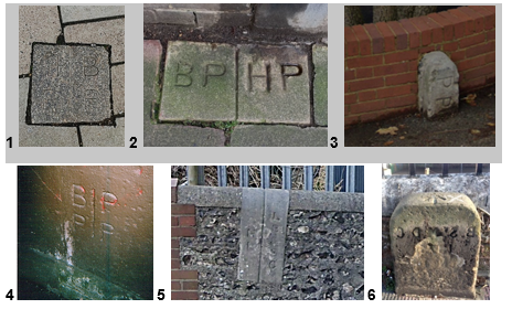
- Western Road Brighton/Hove boundary north side near Bankers – Granite stone inlaid in pavement (Photo 1).
- Windlesham Avenue/Osmond Road south side - two stones side-by-side inlaid in pavement at back edge, on south side of Windlesham Avenue (Photo 2).
Brighton, Hove, Preston Parish Boundary Stones:
- Dyke Road, Old Shoreham Road - upright stone against wall at back edge of pavement denoting Preston Parish (Photo 3).
- New England Road - between pedestrian walkway and New England Road, incised on the east facing base of a pier of railway bridge (Photo 4).
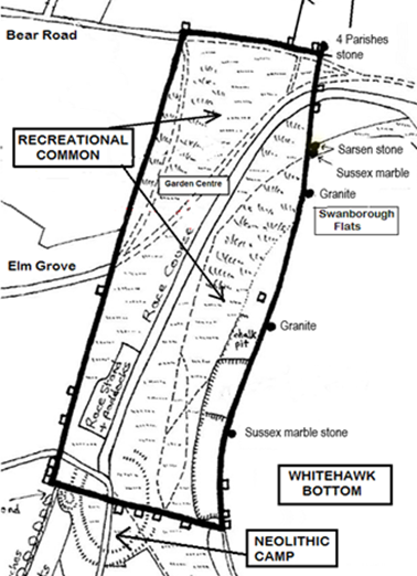
Whitehawk Hill Boundary Stones:
- Six boundary stones or markers on Whitehawk Hill to the ancient Racehill Common, including. Brighton/Ovingdean Parish, Brighton Parish, Race Ground Whitehawk Hill. These boundary stones are free standing and made of granite, sarsen stone or Sussex marble stone (Map 7).
London, Brighton and South Coast Railway (LB&SC)/ H Longhirst's Land (HL)
- North side New England Road underneath the railway bridge - between London, Brighton and South Coast Railway and H Longhirst's land. Mr Longhirst was owner of the Amber Brewery, which owned the former Bridge Inn in New England Road. The Inn was demolished when the slip road was constructed from New England Road to Old Shoreham Road (Photo 5).
St Martins District (BStMDC):
- Elm Grove - Boundary stone, set to back edge of pavement against boundary to Elm Grove Primary School. Rectangular in section, with flat face to front and semi-circular rounded head. Front face is inscribed ‘BStMDC 1875’ with arrow above. The initialism likely stands for ‘Boundary St. Martin’s District Council (or committee/commission)’; the arrow identifies the location of the District’s boundary (Photo 6).
A. Architectural, design and artistic interest
i. The boundary stones and markers are generally functional features but are constructed of various, attractive types of stone and in different formats to suit the location. Artistic interest exists in the form of the incised lettering in various fonts.
B. Historic and evidential interest
ii. The stones are Illustrative of – and evocative of - the different parishes and landholdings that historically formed what the is now the city of Brighton and Hove and so record the expansion of the conurbation.
v. Representative of a time after local parishes became responsible for their own upkeep and, therefore, boundary markers became important. ‘Beating the bounds’ rituals were used to remember land boundaries and there is reference to the boundaries being beaten in Brighton. The boundary stones and markers in their current contexts may reflect changes in human activity since they were installed.
F. Intactness
i. These boundary markers all generally survive intact, though some have been impacted by raised ground levels and some have sustained minor damage and weathering.
Date of inclusion
2023
Map showing locations of boundary stones at Whitehawk Hill