Area covered by the new City Plan
If you would like a shapefile of the area covered by the City Plan, send an email to the Planning Policy Team.
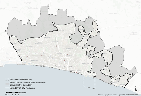
Description of area covered by the City Plan
The Brighton & Hove City Plan area includes all land inside the Brighton & Hove city council boundary except those parts that are within the South Downs National Park (SDNP).
This area encompasses the main built-up city and its urban fringe (parks, open spaces, and edges of the downland) from North Portslade Village and Mile Oak in the west to Rottingdean, Ovingdean, Woodingdean and Saltdean in the east, generally south of the A27.
It covers wards such as:
- South Portslade
- Westbourne and Poets’ Corner
- Westdene and Hove Park
- Patcham and Hollingbury
- Moulsecoomb and Bevendean
- Coldean and Stanmer
- Woodingdean
- Whitehawk and Marina
- Rottingdean and West Saltdean.
Land within the SDNP is managed separately by the South Downs National Park Authority.
- Relationship to the council boundary: The City Plan boundary sits within the council boundary, which is broader because it includes National Park land.
- South Downs National Park: Where the council area crosses into the SDNP, those areas are excluded from the City Plan and form its outer edge.
Boundary description (west to east)
The boundary starts on the western seafront near Shoreham Harbour (Basin Road South), follows the council edge with Adur inland and east, close to the A27 past Mile Oak (South Portslade), towards Carden Avenue between Patcham and Hollingbury (both in Patcham & Hollingbury).
The boundary turns south around the built-up edge by Hollingbury and Moulsecoomb (Moulsecoomb and Bevendean), skirts developed areas around Falmer (including the University of Sussex and Falmer Stadium, on the edge of Coldean and Stanmer) and continues down the eastern side of Bevendean and Woodingdean (Woodingdean), with SDNP countryside such as Hollingbury Hillfort excluded.
From Woodingdean the boundary heads towards the coast past Whitehawk, Roedean and Brighton Marina (Whitehawk and Marina); as the SDNP reaches the coast here, the boundary resumes east of the Marina near Rottingdean High Street (Rottingdean and West Saltdean.